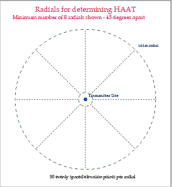
 How is the HAAT determined? A HAAT value is determined by taking 50 evenly spaced elevation points (with the elevations above or below mean sea level [AMSL]) along at least 8 evenly spaced radials from the transmitter site (starting at 0 degrees [True North]). The 50 evenly spaced points are sampled in the segment between 3 to 16 km (originally 2 to 10 miles) along each radial. The elevation points along each radial are averaged, then the several radial averages are averaged to provide the final HAAT value. Terrain variations within 3 km (2 miles) of the transmitter site usually do not have a great impact on station coverage.
Only the 3 to 16 km segment of each radial is used. When the concept of antenna height above average terrain was developed for VHF and UHF radio and television in the late 1930s and 1940s, the process for determining HAAT was a manual one. An engineer would lay out topographical maps covering a radius of 10 miles from the transmitter site, draw 8 radials spaced every 45 degrees, and then find the elevations for 50 evenly spaced points between 2 and 10 miles from the transmitter site for each radial. He would then average the elevation points for each radial, and then average the 8 radial averages to obtain the HAAT. Needless to say, this procedure is very tedious. In 1984, the Commission permitted applicants to use terrain databases in the computation of HAAT (see the July 13, 1984 Public Notice), and permitted applicants to include additional evenly spaced radials. The Commission did not extend the radial segment for calculations beyond 16 km.
Terrain roughness adjustment cannot be used. In 1975, the Commission adopted a terrain roughness adjustment for predicting coverage, and shortly thereafter suspended it after numerous reports of inconsistent results. The rule suspension remains in effect today. See the Development of FM and TV Propagation Curves documents posted on the FCC's website.
HAAT values obtained here may not match the values listed in the FM Query or the TV Query. Several factors can influence the determination of a HAAT value. Different terrain databases, or manual computations using topographical maps, may produce different interpolated elevations for points along a given radial. The number of evenly spaced points sampled along each 3 to 16 km radial segment also influences the average elevation AMSL determined for a given radial. Varying the number of evenly spaced radials can affect the final HAAT value. For these reasons, the Commission retained the manual computation method as the standard in cases where a HAAT value is of questioned accuracy. HAAT values determined here are generally suitable for applications submitted to the Commission, although use of this program is not required. For clarity, applications to the FCC should state which terrain database was used and the number of evenly spaced radials considered.
;Antenna height above average terrain, along with the Commission's FM and TV propagation curves, is commonly used in the prediction of coverage by television stations and by FM radio stations (see Section 73.313 for FM radio stations and Section 73.684 for television stations) as well as some wireless radio services (see rule section 90.205). FM or TV coverage can be extended or shortened in a given direction depending on the height of the terrain in that direction. For example, a mountain may limit service (as compared to flat terrain), while a valley may allow extended coverage. The HAAT value represents an average of the terrain elevations within 16 km (10 miles) of the transmitter site, and so provides a single value on which general coverage calculations and regulatory requirements (such as FM broadcast station classes) may be based.
Notes about the HAAT calculations. The HAAT program includes the full 3 to 16 km radial segment for each radial, and will not calculate radial average elevations AMSL for truncated radials (shorter than 16 km). The default terrain database is the newer GLOBE data, however, the FCC's legacy terrain database for the continental 48 states (early 1980s) is available as an option. Should FCC terrain database data not be found for a given location, the search will default to GLOBE data. Users in the USA can enter coordinates in either the NAD27 or NAD83/WGS84 coordinate systems, and this program will make the appropriate conversion. Users outside the USA should use NAD83 or WGS84 coordinates, although in most instances any difference in the HAAT values caused by differing coordinate systems is typically small.
Source code for this program is not presently available. This HAAT program is derived from code used by the FCC to read the agency's 30 second terrain database, as well as additional code posted at NTIA's Institute for Telecommunication Services.
Dale Bickel [email protected]
Senior Electronics Engineer
Audio Division, Media Bureau
Federal Communications Commission